Rain Bombs
Season 53 Episode 5 | 53m 24sVideo has Audio Description
A deadly—and growing—global weather phenomenon mystifies scientists.
An invisible force is causing chaos around the globe. Follow scientists racing to understand the catastrophic "rain bombs" that are sinking ships and downing planes. Can they learn to predict these devastating weather events and save lives?
See all videos with Audio DescriptionADProblems playing video? | Closed Captioning Feedback
Problems playing video? | Closed Captioning Feedback
National Corporate funding for NOVA is provided by Carlisle Companies. Major funding for NOVA is provided by the NOVA Science Trust and PBS viewers.
Support provided by:


Rain Bombs
Season 53 Episode 5 | 53m 24sVideo has Audio Description
An invisible force is causing chaos around the globe. Follow scientists racing to understand the catastrophic "rain bombs" that are sinking ships and downing planes. Can they learn to predict these devastating weather events and save lives?
See all videos with Audio DescriptionADProblems playing video? | Closed Captioning Feedback
Where to Watch NOVA
NOVA is available to stream on pbs.org and the PBS app.
Buy Now

NOVA Labs
NOVA Labs is a free digital platform that engages teens and lifelong learners in games and interactives that foster authentic scientific exploration. Participants take part in real-world investigations by visualizing, analyzing, and playing with the same data that scientists use.Providing Support for PBS.org
Learn Moreabout PBS online sponsorship♪ ♪ (wind roaring) (thunder clapping) NARRATOR: A freakish kind of weather event... We should not be here.
(chuckles) HANK SCHYMA: I know.
NATCHAYA SCHYMA: I'm shaking right now.
NARRATOR: ...is now striking again and again.
LAUREN BEEHAN: People were panicking, running, taking cover.
NARRATOR: Intense... REPORTER: Batten down the hatches for the potential for straight-line wind gusts in excess of 75 miles an hour.
(car alarm wailing) NARRATOR: Highly localized.
MIKE OLBINSKI: That thing just collapsed right on those mountains and all that air is just exploding.
(thunder claps) NARRATOR: And devastating.
MAN (shouting): Get away from the glass!
SUE VAN DEN HEEVER: It sucked windows out.
There was glass everywhere.
NARRATOR: They fall from the sky without warning.
Explosions of wind and water so violent, they can flatten homes in seconds.
They're known as rain bombs.
And they're getting stronger.
The damage each year just continues to pile up and up and up.
NARRATOR: Now researchers are attempting to understand these destructive weather events.
♪ ♪ In some cases, it can look like a bomb went off.
NARRATOR: Trying to predict where they'll drop and when.
REPORTER: It's not safe to be outside-- you've got about 20 minutes until this severe storm passes through.
NARRATOR: "Rain Bombs."
Right now, on "NOVA."
♪ ♪ ♪ ♪ NARRATOR: August 2011.
The Pukkelpop Music Festival, Belgium.
Out of nowhere, the skies darken... (wind blowing) ...as powerful winds gust at over 80 miles per hour.
(people yelling) MAN (on loudspeaker): Please exit the tent!
NARRATOR: Stages collapse.
Very quickly, within a couple of minutes, it became probably the heaviest rain I'd ever seen.
NARRATOR: Lauren Beehan was 19 when she and her friends traveled from Ireland to Belgium for the festival.
(rain pelting, people yelling) BEEHAN: You couldn't see anything, really.
There was wind blowing debris.
It was very much a case of feeling like we were trapped.
(rain pelting, wind howling) For it to turn from such a sunny, cloudless day to something apocalyptic in the space of 20 minutes is frightening.
It's like something from a disaster movie.
NARRATOR: 140 people are injured and five festivalgoers lose their lives.
♪ ♪ August 2024.
A super-yacht called the Bayesian sinks off the coast of Sicily.
(wind howling, rain pelting) CCTV from the shore that night catches the vessel's mast, lights barely visible, in the 100-mile-per-hour wind gusts and rain.
It drags anchor, then capsizes.
Divers recover seven bodies from the wreckage.
(rain pelting) July 2018.
In heavy rain at Durango International Airport, Aeroméxico Connect Flight 2431 is cleared for takeoff.
(woman screams) (people clamoring) MAN: Jesus (muted)!
MAN: No sabemos si fue un rayo o un problema mecánico.
NARRATOR: The aircraft crashes back down to Earth before it even clears the runway.
Miraculously, there are no fatalities.
♪ ♪ Each of these events was caused by a mysterious weather phenomenon, recognized only in the last 50 years.
♪ ♪ Each began with a thunderstorm, but what followed was much more violent and unexpected.
Highly localized, sudden, and extreme rainfall and low-altitude, high-speed winds.
They're nicknamed rain bombs, but scientists call them downbursts.
So, what are they?
And what causes them?
♪ ♪ (car approaching) (engine stops) (car door closes) Mike Olbinski is one of the world's foremost thunderstorm photographers.
After 15 years of chasing storms, he's mastered the art of being in exactly the right spot at the right time to photograph an elusive weather phenomenon.
Rain bombs exploding from the sky.
His images can help scientists understand how these weather systems form and how they detonate.
We have an updraft going up right to our west, and then this big storm is forming right behind it, and I can see it on the horizon, so I think we need to get a little bit more west.
♪ ♪ Growing up in Phoenix, we used to watch lightning storms, you know, outside at night.
I loved them, and I've always loved them, and I traced it back to seeing a lightning bolt strike behind my house.
I still have this insane, vivid memory of it happening.
NARRATOR: Mike is on the hunt for rain bombs.
These intense weather events are striking with greater strength than ever.
To track one down, he first needs to find a developing thunderstorm.
(directional clicking) But what is the difference between a rain bomb and a run-of-the-mill thunderstorm?
ANDREAS PREIN: In a normal thunderstorm, you get heavy rainfall, lightning, and sometimes hail.
And this can happen over hours.
NARRATOR: A thunderstorm can drop rain at about two inches per hour.
A rain bomb can triple that rate.
And in a rain bomb, the rain and hail aren't just falling to the ground.
They're being thrown down by hurricane-force vertical winds.
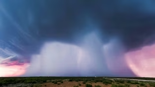
MARSHALL SHEPHERD: What does a rain bomb look like?
It looks a massive volume of rain and cold air coming from cloud base to the surface.
(wind howling) (thunder claps) ♪ ♪ NARRATOR: Across the planet, there are 2,000 electrical storms generating thunder and lightning at any given moment.
(thunder crashing) Each one of them releases more energy over its lifetime than the 15-kiloton atomic bomb dropped on Hiroshima.
Every rain bomb forms from a developing thunderstorm, but to understand how, we must first understand how clouds form.
♪ ♪ When sunlight hits the Earth, the surface heats up, and water from oceans, lakes, soils, and plants starts to evaporate, turning into water vapor.
That water vapor and the warm air around it start to rise.
As it starts to rise, it takes all of the water vapor near the surface of the Earth up into the atmosphere.
As it lifts that up in the air, that parcel of air cools.
The colder the parcel, the less able it is to carry around that water vapor, and so it forces it out into the formation of cloud droplets.
NARRATOR: Clouds form where the water vapor condenses into tiny water droplets, so small and light that they stay aloft, instead of falling as rain.
The altitude where this happens is called the cloud base.
VAN DEN HEEVER: You see lots of little clouds developing, and they all have the same cloud base.
So the cloud bases are actually occurring at the same temperature, and hence the same height.
NARRATOR: In Arizona, the summer monsoon season has arrived.
It carries moist, warm air from the Gulf of California, the perfect fuel for thunderstorms and rain bombs.
OLBINSKI: We can feel it in the air, that it's really humid out, there's moisture, it's warm, so we've got the environment for, for storms to form.
We're seeing these strong cauliflower kind of shape to the top.
When you're seeing that, you've got to imagine how intense that is to go from nothing to this sharply defined cloud.
And then a couple of them get a little bigger, and then you get something like this, where, boom, it erupts.
♪ ♪ NARRATOR: If the conditions are right, these simple clouds can turn into thunderstorms.
SHEPHERD: When you have these puffy, fluffy clouds that you see in the sky, there are some interesting things going on inside.
Condensation is happening, and heat is actually being released as water vapor is changing to water.
NARRATOR: As the water vapor cools, it condenses into droplets that form a cloud, warming the surrounding air.
The now-warmer air rises, creating more updraft, lifting more air higher into the cooler atmosphere, where even more water can condense, which further warms the air.
If the conditions are right, with enough moisture rising into cold air above, this fuels a positive feedback loop that intensifies the cloud's growth.
♪ ♪ OLBINSKI: I see, like, a whole line of updrafts going up, so I like that.
A lot of these tops today, they just look really strong.
Sometimes you got the towers going up, but they don't have the same kind of powerful look.
They're bubbly like a cauliflower, but they're just a little less intense.
Well, a couple of these, if you look at them, they just look like there's so many areas where it's just knuckle-y and explosive-looking.
Oh!
I just saw two big bolts strike way out there on the horizon-- whew!
But I think something big's going to happen here.
It's a nice, large, dark area.
This is probably going to turn into a really strong storm.
I would expect, I would hope.
I'm trying to catch some lightning right now.
I'm doing two timelapses.
(camera shutter clicks) Lightning is an indicator that the updraft is tall enough to have ice and hail.
(thunder crashes) NARRATOR: Ice and hail are key ingredients that drive the most powerful rain bombs.
But how does something as solid as ice or hail form and stay aloft in the atmosphere?
When water vapor condenses in clouds, it releases an extraordinary amount of energy.
That makes our clouds very turbulent and that lifts the air higher up in the cloud.
At some point in time, that air will cross over what we call the freezing level to form things like snowflakes and hailstones, and that change in phase, of course, releases more energy.
NARRATOR: This energy, in the form of heat, drives the further growth of the cloud, expanding upward to the very top of the troposphere, up to 12 miles above ground level.
Above the troposphere sits a warmer band of air called the stratosphere.
This warm air acts as a lid preventing the cloud from climbing any higher, so it spreads out flat, forming a distinctive anvil shape.
So we've gone from the development of a tiny little fluffy cloud to these very tall, extensive storms that are now carrying around large amounts of hailstones and snowflakes.
This storm is now seriously ready to do business.
(thunder claps) NARRATOR: Lightning bolts are a telltale sign that a cloud has developed into a thunderstorm.
(thunder claps) Raindrops get so big, they're too heavy to be held by the cloud's updraft, and so it begins to rain.
Or, if conditions are right, it can go on to develop into a violent rain bomb.
(thunder rumbling) To understand why some thunderstorms collapse into rain bombs, it helps to know what's going on inside that rain cloud.
One way to uncover that is to analyze the stuff that falls out.
Particularly hailstones, icy chunks of frozen cloud.
(thunder rumbling) Over the summer of 2025, storm researchers teamed up on a project called ICECHIP to collect hailstones from thunderstorms striking the Great Plains.
BECKY ADAMS-SELIN: The ground teams, the teams looking at what kind of hail fell at the surface, is really what made this campaign unique, because other campaigns, you know, would go and, and look at, at storms with mobile radars, and that's a lot of great information, but only ours also tried to really fully characterize what kind of hail was down at the surface.
♪ ♪ NARRATOR: The ICECHIP team brings the hailstones to a cold lab in Boulder, Colorado.
Here, at below-freezing temperatures, atmospheric scientists Anthony Bernal Ayala and Becky Adams-Selin process and analyze each of the thousands of samples.
Large hailstones are extremely valuable in understanding more about the thunderstorm they came from.
(saw whirring) Once you get the hailstone, you can actually just go ahead and cut a thin slice out of it.
And you polish it up so it's an even thickness.
You can get a lot of information just by looking at the slice.
You can see different rings in the hail, and much like tree rings, those represent different conditions under which the hail was growing in the storm.
When we look at hailstones and we look at the cross-section, one of the things that we look at is whether the layer is opaque or whether layer is clear.
When you look at that clear layer, you're looking at where there is warmer sub-zero temperatures, so it's a little bit warmer in the cloud, where liquid water freezes slowly, and because this freezes slowly, that allowed the air bubbles to escape.
So it's gonna be clear-- there's not gonna be a lot of air bubbles trapped in this layer.
When you look at the opaque layer, because it's in temperatures in the cloud that are very cold, it's gonna freeze very rapidly.
(snaps) So, because it freezes very rapidly, it actually traps a lot of air bubbles in that layer, so that it actually looks opaque.
NARRATOR: But why would a single hailstone have both clear and opaque layers?
And what does that reveal about how the hailstone formed?
The hailstone had to have been moving around in the storm to experience these different conditions and to create the different layers.
We think that it's actually rotating somehow around the updraft to accumulate all those layers that we see in the cross-section.
NARRATOR: These layers are evidence that the hailstones are continually rising and falling inside a developing thundercloud.
BERNAL AYALA: This hailstone spent most of its time in very cold temperatures in the cloud, but for a very short period, it actually went through a warmer side of the cloud.
Then it went back, a very cold temperature, then it went back, a warmer section of the cloud, where it probably fell and then it was collected at the surface.
NARRATOR: To grow to two inches wide, this hailstone most likely spent over half an hour being lifted and dropped inside the storm.
(thunder rumbling) There's updrafts, there's downdrafts.
There could be hail.
There could be circulations or rotations inside that cloud.
VAN DEN HEEVER: These intense storms are very turbulent.
They have regions where air is rising very rapidly, sometimes at speeds of 150 miles per hour.
(thunder claps and rumbles) NARRATOR: This mixing of hail and ice provides the energy necessary for the storm to produce thunder and lightning.
(thunder claps and rumbles) In mature thunderstorms, like the one that made Anthony's hailstone, immensely powerful updrafts can suspend over a million tons of hail miles above the ground.
It's actually quite incredible that storms are able to suspend this large mass of liquid raindrops and other ice, like hail and snowflakes, so high up in the atmosphere.
NARRATOR: What happens to this core of rain, hail, and ice determines whether the storm remains a regular thunderstorm or unleashes a rain bomb.
♪ ♪ OLBINSKI: Dude, that looks freaking awesome.
That's just plummeting-- that's, like, a downburst happening.
When you see that middle rain shaft area, where it looks like a blob, that's usually a good telltale sign of a downburst happening.
Oh, man.
This is stunning.
♪ ♪ NARRATOR: In a fully developed thunderstorm cloud, what goes up must eventually come down.
The cloud's updraft begins to peter out as rising air cools and sinks back toward the ground as a downdraft.
This is what happens in a standard thunderstorm.
But in a rain bomb, things are different.
Because in a rain bomb, a sudden, extremely strong downdraft overwhelms the updraft, causing the cloud's core of ice and hail to collapse all at once.
Two processes drive this sudden downdraft intensification.
The first is that, as the rain and hail start to fall downward, they drag on the air.
So they pull the air down toward the Earth.
♪ ♪ NARRATOR: When massive amounts of rain and hail begin to fall, they help generate a downward rush of air, which can act as the rain bomb's trigger.
But that's not all that's required to get a rain bomb started.
The second, more important process that accelerates this developing downburst toward the ground is evaporation.
Evaporation is a cooling process.
You experience it when you step out of a swimming pool or your shower.
VAN DEN HEEVER: When you've got drops of water on your skin, as these drops evaporate, your skin feels very cold.
NARRATOR: If winds blowing into the cloud are dry, they can rapidly evaporate raindrops, as well as melt ice and hail.
This cools the surrounding air, making it denser and heavier.
VAN DEN HEEVER: This very cold air, very dense air, has to sink.
So it's going to rush toward the surface, taking all of that large mass of rain and hail.
NARRATOR: As rain and hail descend from the cloud, if they hit more dry air, the evaporation can accelerate further.
VAN DEN HEEVER: As the raindrops fall below cloud base into this drier air, they will evaporate in that location, too.
This, of course, is going to really intensifies that cooling process.
This very cold, dense air then rushes toward the surface, creating these phenomenal scenarios called downbursts or rain bombs.
(wind blowing) NARRATOR: The downdrafts can intensify into hurricane-force vertical winds, driving the cloud's core of hail, rain, and cold air downward, slamming it into the ground.
Sometimes, the downburst's rain can completely evaporate before reaching the ground, creating what scientists call a dry downburst.
And all of these downbursts, both wet and dry, can strike in just a few minutes, in a remarkably narrow column, as small as just a couple of hundred yards across.
And as our atmosphere warms, they're becoming more and more powerful.
It actually can be quite a frightening moment.
There's a lot going on.
There's lightning, there's hail, there's very heavy rain, and then, of course, the strong wind.
♪ ♪ NARRATOR: Storm chaser Hank Schyma has been caught under a powerful rain bomb.
HANK SCHYMA: There was a day where I get slammed by a downburst.
♪ ♪ The rain really picks up and gets really strong, everything turns white, and then, all of a sudden, I can see that I'm about to drive off the road.
(thunder claps) You can feel the winds rocking your car, and, and the winds are picking up sand and things in the road, and they're slamming them into your car.
It's really terrifying and scary.
♪ ♪ NARRATOR: Strong winds are a key element of downbursts.
They slam cold air into the ground at high speed.
And this air has to go somewhere.
They can't go into the ground, so they spread out horizontally in all directions.
So, you see extreme surface winds.
NARRATOR: Cold air hits the ground and pushes out radially from the heart of the downburst.
VAN DEN HEEVER: This outflowing air-- remember, it's very cold, dense air-- we refer to as a cold pool, because it is a cold pool of dense air.
♪ ♪ NARRATOR: These advancing banks of cold air can kick up dust, creating the distinctive dust storms often seen in the American Southwest.
VAN DEN HEEVER: Dusty cold pools are called haboobs.
And they create all sorts of severe weather, including visibility issues, road accidents, and breathing issues.
NARRATOR: The dust makes the turbulent gust front of an advancing cold pool easy to see.
But even when no dust is present, this billowing front of cold air is still there.
And it's these fierce straight-line winds that inflict the most damage.
VAN DEN HEEVER: These winds are strongest near the surface.
If you compare that to something like a hurricane, a lot of the strength in a hurricane exists higher up in the atmosphere.
But for downbursts, they occur very close to the surface.
Trees will just flap down to the ground, and these wind gusts are so strong that you cannot stand on your own feet anymore.
In some cases, it can look like a bomb went off.
Literally, that air hits the ground at low levels and spreads out in all directions.
VAN DEN HEEVER: Those winds are what we call straight-line winds.
They are not turning like a tornado turns.
They are following straight lines away from where the downburst hits.
(thunder rumbling and crashing) (rain pelting) NARRATOR: This might explain what happened to Aeroméxico Connect Flight 2431 when it took off from Durango International Airport, en route to Mexico City.
The rain, while heavy, was not extreme.
VAN DEN HEEVER: There were storms in the area, but the tower had cleared them for takeoff and had told them that they actually have headwinds, which would provide them lift for takeoff.
NARRATOR: Without realizing it, Flight 2431 flew through a downburst.
In just seconds, the plane experienced a near 180-degree shift in wind direction.
The plane was about 30 feet off the ground, a very susceptible time on any takeoff, and this tailwind, it swung from being an uplift to a sinking motion.
NARRATOR: Without the lift generated by a headwind, the plane plummeted and crashed into the runway.
♪ ♪ (woman screams) (people clamoring) (people screaming) ♪ ♪ Luckily, everyone managed to escape before the plane was fully engulfed in flames.
This wasn't the first passenger jet to crash in similar conditions.
June 1975.
Eastern Airlines Flight 66 crashed on approach to JFK.
August 1985.
Delta Flight 191 crashed on approach to Dallas Fort Worth.
July 1994.
U.S.
Air Flight 1016 crashed on approach to Charlotte Douglas International Airport.
♪ ♪ VAN DEN HEEVER: Those tragic accidents in the '70s and '80s led to a lot of very significant research in downbursts, how they operate, and then subsequently, the technology that we need to warn pilots.
A lot of the airports in the U.S.
are fitted with these weather radars, but there are many of the airports around the world do not have this technology.
Aeroméxico flight would not have taken off had they been aware of the fact that they were just about to hit a downburst.
NARRATOR: When investigators study the loss of the supposedly unsinkable Bayesian yacht, which went down on August 19, 2024, they discover that before it capsized and sank, it had dragged its anchor around 400 yards in a dead straight line.
VAN DEN HEEVER: The Bayesian was anchored off the north coast of Sicily.
It was in a bay, it was next to another yacht.
(wind howling, rain pelting) NARRATOR: This CCTV footage from a camera onshore about 600 feet away reveals the boat in the distance.
VAN DEN HEEVER: What ended up happening was, as these really strong straight-lined winds hit these yachts, they dragged anchor in straight lines.
That indicates it was a straight-lined wind, as opposed to the kind of rotational wind you would get from a tornado.
And it was a very large yacht with a very tall mast and it would appear that the downburst and associated cold pool was actually able to roll it over beyond its point of stability.
NARRATOR: The yacht succumbed to the same type of extreme low-altitude, straight-line winds that led to the crash of Flight 2431.
(wind roaring, rain pelting) At the Pukkelpop Festival in 2011, the hail and howling winds struck an area less than a hundred yards across.
VAN DEN HEEVER: This was a very narrow downburst.
This is what made it so unusual.
You would normally expect such power from systems that are larger, where they can transport more rain and more hail and more wind to the surface than in a 100-meter-wide downburst.
So, a really remarkable event.
(sirens wailing in distance) NARRATOR: These real-life tragedies reveal the destructive potential of powerful rain bombs: intense, highly localized, and short-lived.
♪ ♪ But a storm that hits Houston in May 2024 has all the hallmarks of a downburst, except that it is much bigger.
It travels around a thousand miles and it lasts much longer than a single downburst-- more than 12 hours.
REPORTER: A line of severe thunderstorms is racing into our Greater Houston area.
You should batten down the hatches for the potential for straight-line wind gusts at about 70, 80, to 90 miles an hour.
NARRATOR: National Weather Service forecaster Amaryllis Cotto is on call at the Houston/Galveston office 27 miles southeast of Downtown Houston when the storm hits.
♪ ♪ COTTO: The storm developed very fast in areas of West-Northwest Texas at around 9:00 a.m., and so we could see how fast it was moving.
It was already affecting the Houston metro area by around 5:00 to 6:00 p.m.
(thunder claps) REPORTER: It's not safe to be outside.
You've got about 20 minutes to get hunkered down on the first-floor interior room of your home, away from windows.
That's the safest place to be until this severe storm passes through.
COTTO: It was devastating Houston.
We had a lot of tree damage.
We had millions of people without power.
NARRATOR: Hank and Natchaya Schyma are five miles north of downtown when the storm hits.
He starts recording the storm from his car.
Suddenly, it goes from daylight to darkness, and chaos hits.
(thunder claps) HANK SCHYMA: Here it comes.
NATCHAYA SCHYMA: Holy (bleep)!
Holy (bleep)!
HANK SCHYMA: Yup, hang on, I've got it.
Um, we should not be here.
(chuckles) I'm shaking right now!
HANK SCHYMA (in interview): You can't see a block in front of you just because of the whitewash of wind and rain, and trees are swaying, and downtown Houston is raining glass, as windows are, are failing all up in the skyscrapers.
MAN (shouting): Move away from the glass!
(people screaming) VAN DEN HEEVER: The winds associated with this system were hurricane-force winds in the lower levels.
It sucked windows out-- there was glass everywhere.
And in addition to the sucking motion, inside the buildings, the pressure is now higher than outside.
So you get this explosive force that forces windows and glass out of the buildings.
♪ ♪ NARRATOR: It's the signature of a rain bomb.
Super-strong ground-level winds shattering any weak windows along their path.
Telltale signs of straight-line wind damage are seen all over the city.
They pull down power lines across Houston and plunge one million people into darkness.
But the Houston storm isn't the size of the storms that hit Pukkelpop or sank the Bayesian.
It's over 50 miles across and leaves a path of devastation across the 10,000-square-mile Houston metro area.
Rain bombs just don't grow this big on their own.
They need to gang together to become this large.
But how?
♪ ♪ 22 miles northeast of Fort Collins, Colorado.
Atmospheric scientist Sue van den Heever's 20-strong team is out in the field.
I think the forecasters are keen to have some surface measurements, Okay.
They are trying to assess the moisture.
NARRATOR: Her team deploys drones engineered to withstand extreme weather.
They measure the outflow winds when the cold air in a downburst crashes to Earth and races across the landscape, forming the cold pool.
♪ ♪ VAN DEN HEEVER: We've launched what we call the flying curtain.
And we're flying a wall of six drones.
We have a lower level of drones and an upper level of drones.
We have a lot of instruments that can measure the temperature, the moisture of the atmosphere.
We've got anemometers on there that can measure the winds.
And this allows us to make measurements of the variability of the atmosphere, and as the cold pool advances on us and blows through us, we are able to make that measurement in time, as well.
So there's a lot that we are characterizing about these cold pools.
(drones whirring) NARRATOR: Sue and her team are tracking a storm a safe distance away, beyond the horizon.
Radar shows that it has produced a downburst of intense rainfall.
The air that slammed into the ground is now spreading out across the plains in a cold pool, coming toward them.
Their radar tracks the dust kicked up by the advancing bank of fast-moving cold air.
ERIN SHERMAN: So we're expecting that cold pool to come through within the next few minutes, so we're waiting to try to collect the data.
NARRATOR: The team will release weather balloons up into the cold pool, to measure temperature, pressure, humidity, and moisture.
♪ ♪ (whirring) ♪ ♪ VAN DEN HEEVER: This cooling of the air you can feel, and the wind you're feeling, that's this boundary that's actually starting to hit us.
So we're going to release that balloon.
(over radio): Everybody ready?
Three, two, one.
(thunder claps in distance) PETER MARINESCU: Oh, and there's some thunder.
(woman chuckles) VAN DEN HEEVER: Please release.
(thunder rumbling) ♪ ♪ NARRATOR: 30 minutes after the rain bomb dropped, that bank of cold air, here graphically rendered to be visible, has covered the 17 miles from the epicenter of the storm and breaks over the flying curtain of drones.
On the ground, the team analyzes the data.
MARINESCU: So right here, we're, we're looking at data from the balloon that we just launched.
What we're looking at is pressure, moisture, temperature, and relative humidity.
And this is telling us the depth of the cold pool that just came through.
So right now, based on the temperature data, we're seeing a decrease in temperature that is going about 500 meters high.
NARRATOR: The team has learned the cold pool reaches 500 meters, or about 1,600 feet high, but that's not all.
These balloon observations allow the team to measure what's happening to the air above the advancing cold pool.
What they've found is that the cold pool acts as a wedge, pushing up an updraft of warm air.
VAN DEN HEEVER: When we have a storm forming a really strong downburst and its associated cold pool, that lifts the surrounding air up and over the edge of the cold pool and forms a new updraft.
That updraft can go on to build another really strong storm.
That storm can then, of course, make its own downburst, its own new cold pool, which can then form another updraft, and so we get into this cyclical process of updraft formation.
♪ ♪ NARRATOR: Background winds can stretch downburst cold pools from circular outflows into fan-shaped fronts.
If atmospheric conditions are primed for multiple thunderstorms, the cold pools can merge into one broad line of advancing cold air.
The advancing boundary lifts warm air ahead of it.
This rising warm air feeds a new generation of updrafts and helps build an even larger storm.
It's a self-sustaining cycle of updrafts, downbursts, and cold pools that sweeps across the landscape.
Meteorologists call this a derecho.
One thing that distinguishes derechos from other types of wind systems is their sheer size and how long they can last.
The longest one on record is some 1,300 miles.
VAN DEN HEEVER: Derechos can stick together for time periods of six to 12 hours.
So these are extensive, very dangerous wind storms.
♪ ♪ NARRATOR: The 2024 Houston storm was a derecho-- an organized system of multiple repeating downbursts that ripped across a thousand miles of Gulf Coast from Central Texas to the Florida Panhandle.
♪ ♪ Back in Arizona, Mike has a hunch that the beginnings of a multi-storm system are brewing west along interstate eight.
OLBINSKI: Oh, man, this storm!
Big towers in the air going up.
Man, this is... This looks frigging great!
♪ ♪ Oh, my God, look at this demon!
(wind roaring in distance) Holy rain bombs!
Now, that's a downburst!
We have a monster rain bomb right here, a downburst of, like, that we haven't seen so far.
I mean, this looks like a bomb went off.
That thing just collapsed right on those mountains, and all that air is just exploding and hitting us.
This is awesome!
(laughs) I could see the towers up there.
They were probably 50,000-plus.
They were kind of twisting-- even right here, I see, like, this updraft has got a little twist to it, and when that happens, it's suspending that rain, because it's rotating, so it's suspending up there more, so then, when it comes down, it just has so much more force.
And all that air, all the stuff we're feeling, it's just blasting from that storm, and it's constant, because there was probably multiple downbursts that happened-- there was, like, an initial one.
There, there was one on the right, one on the left, and then just, like, the main thing went down, and now we're getting this dust that's appearing right here.
(wind roaring) NARRATOR: The dusty outflow winds from the rain bombs are racing west, and Mike jumps in his vehicle to get ahead of the growing storm and reset in a new position.
♪ ♪ OLBINSKI: There's-- you can kind of make it out.
So, we actually have a dust storm coming.
So just overall, it's getting better as it goes west.
(thunder claps) Oof, lightning!
This dust in there is looking good.
This dust is just food coloring in the atmosphere.
Basically, the dust and the shelf structure are showing us the outflow, or the cold pool, where it's all consolidated and pushing.
But without the dust, you don't get to see what the air's actually doing.
This is gorgeous-- the color, this is what... This is what you live for.
But this is the result of stronger downbursts that consolidated and just formed intense outflow.
This is amazing!
What?!
♪ ♪ Whoa, it's making them disappear now!
(wind roaring) What a day!
What a day!
♪ ♪ NARRATOR: This dust storm produced winds of over 55 miles per hour.
It was the result of multiple microbursts organizing into a larger system, creating a macroburst.
If this dust-filled cold pool had hit Phoenix instead of the desert, it could have caused extensive damage.
And if it had grown further, it could have become a derecho-- exactly what hit Houston.
Downbursts and derechos are dangerous wherever they strike, but especially so when they hit built-up areas.
So is there any way to protect against them?
♪ ♪ (birds twittering) Ian Giammanco is lead meteorologist at the Insurance Institute for Business and Home Safety, the IBHS.
His team investigates how a downburst's devastating combination of wind and hail inflicts damage on property.
When wind attacks a building, it's always looking for the weakest link in that chain.
And a lot of times, that is at the edges of roofs or if an opening, say, a garage door, a window, a door fails, and that air is allowed to rush in.
♪ ♪ NARRATOR: They use a monster wind tunnel to test the construction standards of North American homes: an extraordinary array of 105 fans.
Each fan is almost six feet in diameter and packs 350 horsepower.
Together, they can produce winds topping 100 miles per hour, just like the Houston derecho.
(wind roaring) Wind is a cascade of damage.
It often starts with one little thing that cascades to the next, to the next, to the next.
And the next thing you know, you're looking at a catastrophic failure.
NARRATOR: To reinforce homes against the destructive power of downburst winds, Ian and the team at IBHS have developed a new building standard.
GIAMMANCO: It's designed to help minimize the amount of damage that comes with severe wind events.
(hail pelting) NARRATOR: The IBHS construction methods include a hail-resistant roof, and also adds anchors and metal connectors to lock the roof to the walls and the walls to the foundations, transferring the wind's force down into the ground.
Build a home to these standards and put it alongside a typical home, and the difference is clear.
(fans whirring) ♪ ♪ GIAMMANCO: As our wind speeds increase, the front door fails.
(door bangs open) That allows wind to rush into that structure and start pushing out.
The fortified home, however, sitting on its right, it's structurally sound-- it can take those forces, whereas the conventionally built home simply couldn't.
And the next thing you know, the wall has failed... (wall breaks) ...and it comes apart.
(wind howling) ♪ ♪ As our atmosphere warms, that's simply producing more fuel for thunderstorms.
It's air that wants to go up.
Those thunderstorms can take advantage of that.
PREIN: In a warming world, you can store more water vapor in the air, so as we have more of this fuel in the air that can then condensate and release heat, these thunderstorms, the derechos, can become more intense.
NARRATOR: As the world warms, there will be more moisture in the atmosphere on average.
But some regions could actually dry out.
Drier air has to rise farther to cool enough to condense, so cloud bases would be higher.
That could have big consequences.
If you had a cloud base of this high and now you raise it to this high, you have so much dry air to put raindrops through, to put hailstones through, that it gives the storm system a lot more time to evaporate and melt.
NARRATOR: More evaporation and melting may mean there is less precipitation hitting the ground, but it also means faster-falling, cold, dense air.
VAN DEN HEEVER: And so there's every reason to expect, with changing climates, stronger downbursts.
PREIN: Derechos already became more powerful over the last 40 years because the air is warmer over the U.S.
nowadays than it was in the '80s.
GIAMMANCO: So, this is a race to get our building codes and get our structures ready to deal with what could be the weather of the future.
NARRATOR: Protecting homes and businesses will reduce the financial cost of future downbursts and derechos.
And better forecasting is also essential.
But weather forecasts face limits because of the inherently chaotic nature of the atmosphere.
If you start a model with slightly different initial conditions, the end results can be very different based on some very simple differences in the initial information we put into our models.
We can't actually accurately predict the weather beyond about 14 days.
NARRATOR: By updating the model every few minutes with live data, the forecast can be nudged back to reality.
But data quality is crucial.
And some of the best data comes from space-based instruments.
French Guiana.
♪ ♪ An Ariane 5 rocket delivers a 4.2-ton next-gen weather satellite into a geostationary orbit, where it stays positioned above Europe and North Africa.
It's one of three satellites that will be co-located in the same orbit to probe the region's atmosphere.
Olivier Brize is part of the team behind this new satellite system.
BRIZE: The Meteosat mission is a geostationary satellite.
You have a constant and stable view of the Earth.
The aim is to improve the short-term nowcasting and also to provide alerts on a severe weather event on a very short term, within one or two hours and within a very small area: on a valley, on a village, on a town.
♪ ♪ NARRATOR: These satellites will provide a 3D profile of the atmosphere above Europe and North Africa, including humidity, wind speed, and temperature.
This real-time view will enable forecasters to spot the warning signs of an atmosphere primed to produce downbursts: rapidly cooling cloud tops or banks of dry air around developing thunderstorms... ...allowing forecasters to give downburst warnings.
BRIZE: For us working on this project, we are convinced that we are in a position to save lives.
NARRATOR: So far, the U.S.
has no equivalent geostationary satellite system, but there are plans for future deployment.
VAN DEN HEEVER: If we want to save lives around the world, we really need global observations, and so, the best way to do this is to build satellite platforms.
SHEPHERD: We've made progress with the forecasting of extreme downbursts and derechos, but there's still a lot of things that we don't know about them.
However, our modeling systems, our observational systems, and our field campaigns have allowed us to really move forward with understanding these storms and better predicting them.
NARRATOR: Earth's atmosphere is a cauldron mixing warm, wet air with cold air above, a mixture that generates huge thunderstorms.
And as the Earth's atmosphere warms, it will hold more moisture and more energy to fuel them.
SHEPHERD: As we move forward with new satellite technology, I believe that our ability to forecast these systems will be even more improved in the next zero to ten years.
NARRATOR: But while we wait for forecasts to catch up, more severe winds, more deadly hail, and more extreme rainfall will mean more devastating rain bombs.
♪ ♪ ♪ ♪ ♪ ♪ ♪ ♪ ♪ ♪ ♪ ♪ ♪ ♪
Video has Closed Captions
Preview: S53 Ep5 | 30s | A deadly—and growing—global weather phenomenon mystifies scientists. (30s)
Providing Support for PBS.org
Learn Moreabout PBS online sponsorship

- Science and Nature

Capturing the splendor of the natural world, from the African plains to the Antarctic ice.
Winnipeg In Bloom


 Recently Added

Support for PBS provided by:
National Corporate funding for NOVA is provided by Carlisle Companies. Major funding for NOVA is provided by the NOVA Science Trust and PBS viewers.